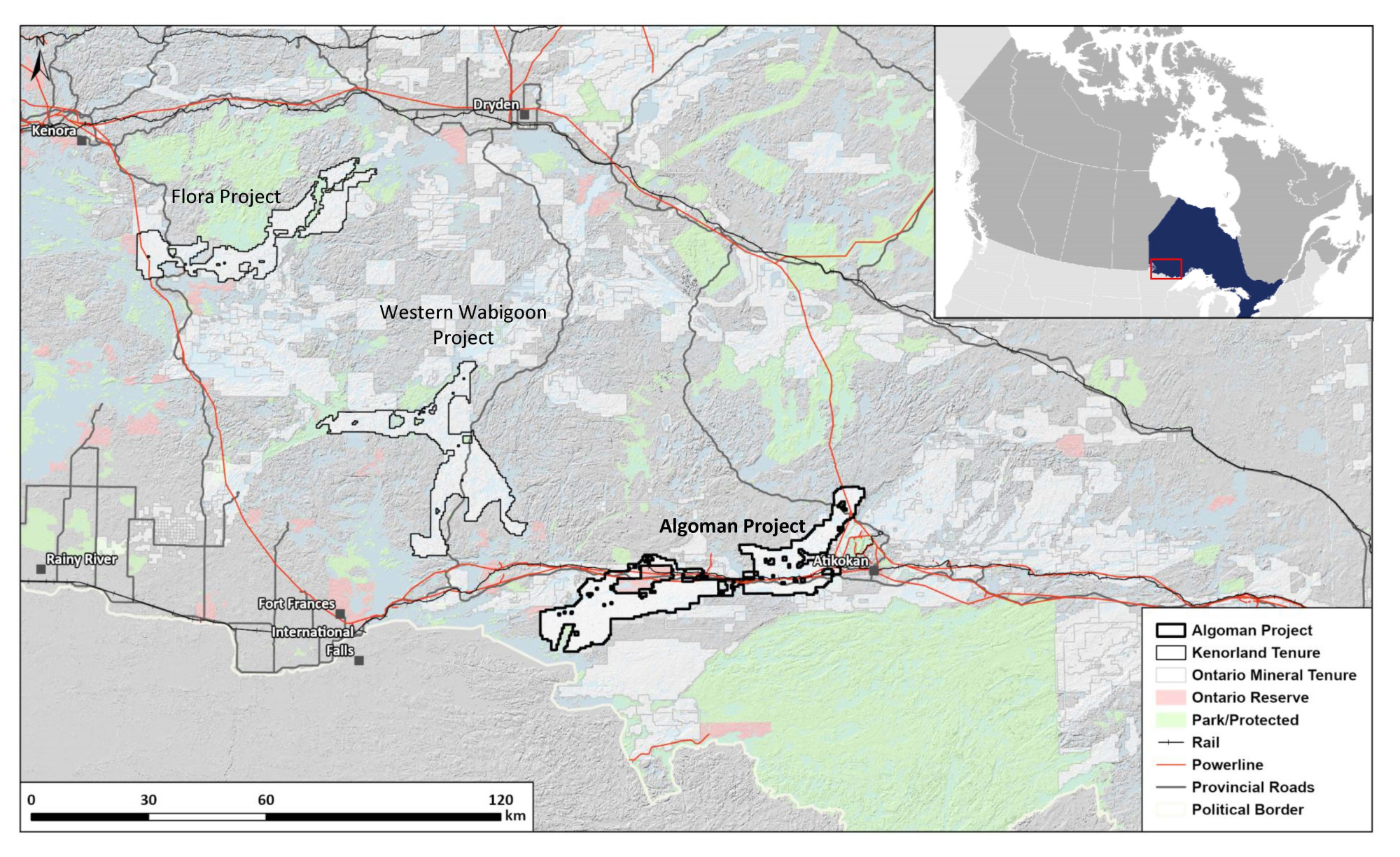
LOCATION
Ontario, Canada
SIZE
96,845 ha
STAGE
Grassroots
DEPOSIT TYPE(S)
Orogenic Au, VMS, Li-Cs-Ta Pegmatite, Magmatic Ni-Cu
The 96,845 ha Algoman Project in north-western Ontario was acquired through staking in 2023 and represents a significant strike length of prospective geology close to infrastructure and in a favourable mining jurisdiction. The Project straddles the boundary between the Wabigoon and Quetico subprovinces, a structural setting favourable for the development of both orogenic Au and Li-Cs-Ta pegmatite deposits. On June 25, 2025, the Algoman Project was optioned to Centerra Gold Inc. under an earn-in agreement, whereby Centerra may acquire up to a 70% interest in the Algoman Project.
Location and Access
The Project is located between Atikokan and Mine Centre in northwestern Ontario, north and south of Provincial Highway 11. Favorable infrastructure exists on the Project including extensive forestry road networks, power transmission lines and rail networks, as well as nearby population centres with exploration services and personnel.
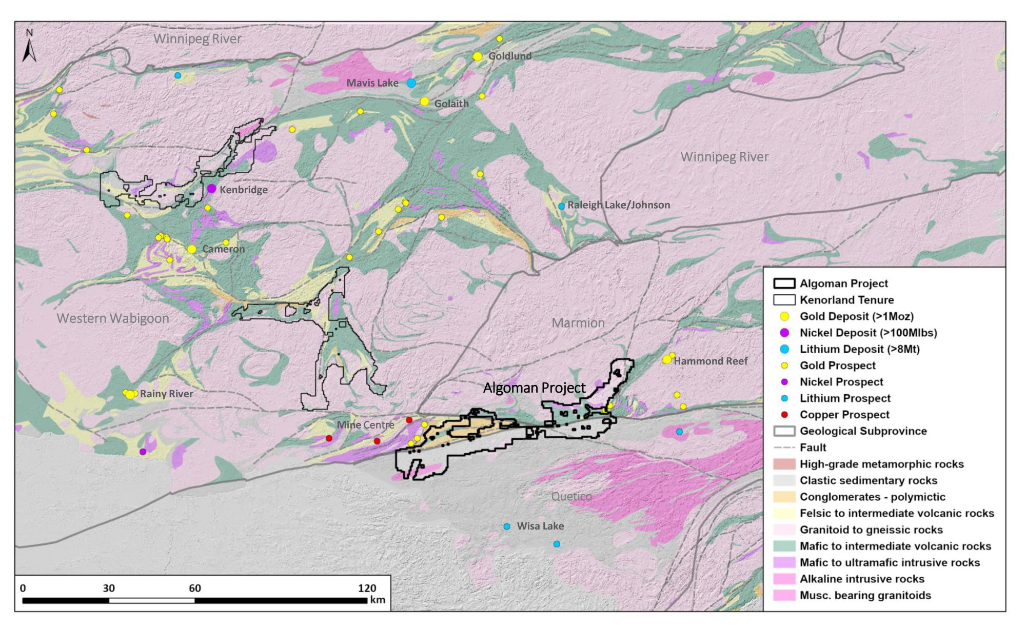
Geology and Mineralisation
The Project area occurs along the structural boundary between the Wabigoon and Quetico subprovinces of the Archean Superior Province. The Wabigoon subprovince includes volcanic and metasedimentary belts and surrounding felsic plutonic batholiths and is transected by several major east-west to northeast striking deformation zones. The Quetico subprovince is dominated by sedimentary migmatite gneissic rocks and felsic plutonic rocks, with major deformation zones parallel to the subprovince boundary.
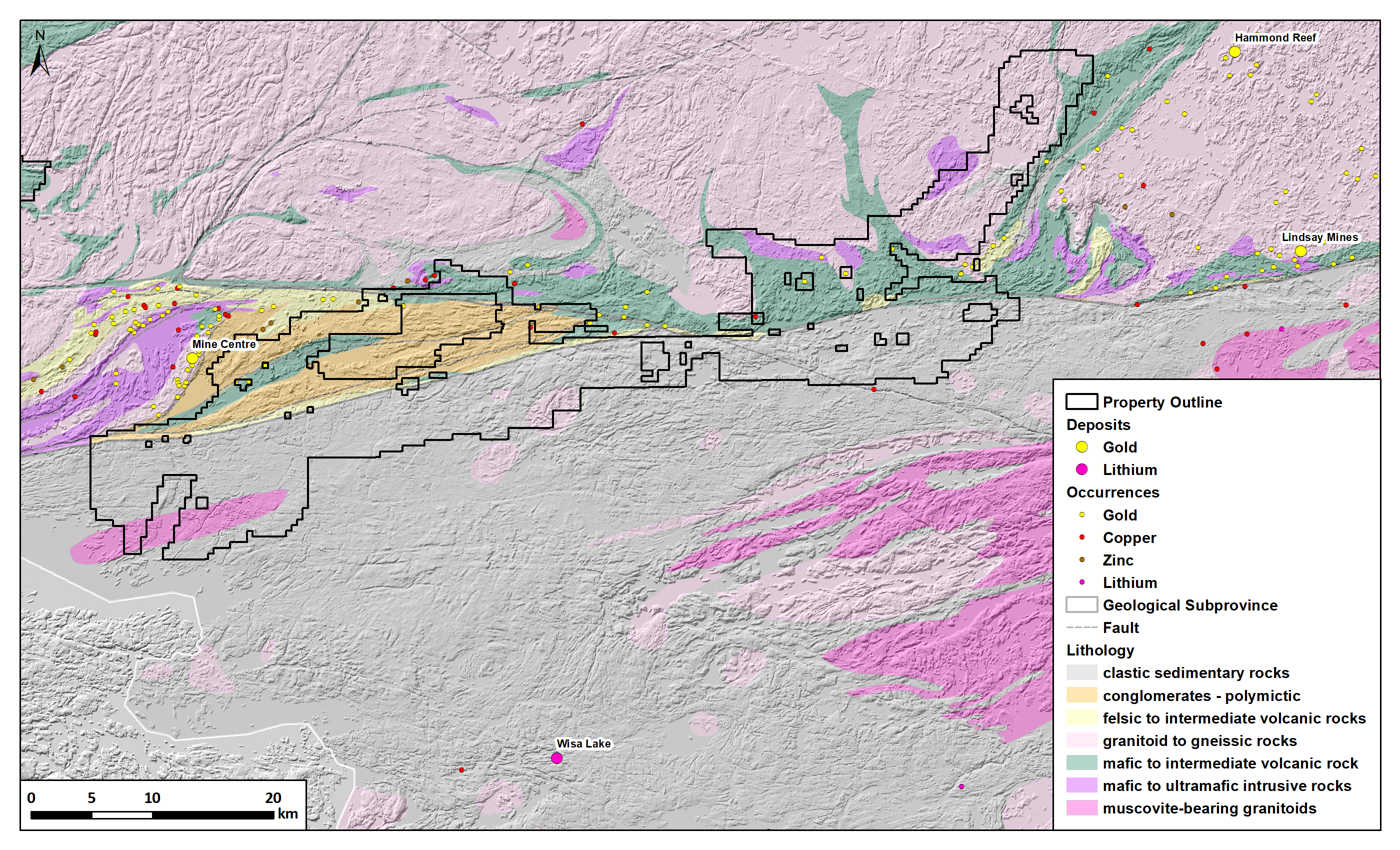
The Project area has potential for several mineralisation styles. The volcanic greenstone belts and structures north of the Seine River and Quetico faults are favourable settings for Au orogenic Au vein and disseminated sulphide hosted deposits, nearby significant orogentic style deposits include Hammond Reef and the deposits at Mine Centre. South of the Quetico fault there are several nearby occurrences of platinum group elements associated with mafic intrusive rocks, as well as actively explored pegmatites associated with evolved granites.
Exploration History
The area has seen exploration, primarily for gold, since the late 1880’s however work has been focused on the past producing orogenic deposits and volcanic rocks of the Mine Centre area. Within the Project boundaries limited drilling totalling 60 holes have been completed. Geochemical work is limited to three lines of 1km spaced till sampling. The majority of the Project has not seen systematic geochemical surveys or high-resolution geophysical surveys.
Summary of exploration activities conducted by Kenorland Minerals
Since staking of the Project in April 2023, Kenorland has completed the compilation and digitization of historical exploration data within the project area. A LIDAR survey was flown by Kenorland in the summer of 2023 to aid in surficial geological interpretation and planning of systematic geochemical surveys.
In the 2024 summer field season, Kenorland completed large-scale geochemical surveys, which included fine fraction till sampling (approximately 3,110 samples) and HMC/MDMC till sampling (approximately 500 samples) for gold grain analysis and spodumene grain counts, covering the 96,845 hectare property. The till geochemical survey outlined two distinct trends of Au-As±Sb-Ag-Cu anomalism, hosted within volcanics and structures sub-parallel to the Marmion-Quetico subprovince boundary immediately to the south. The A1 target (see figure in Gallery Section) is spatially associated with the intersection of the regional Quetico Fault and the Rainy Lake-Seine River Fault system. The A2 target, located 19 km to the east, lies along trend with other known high grade gold mineral occurrences further to the east, including the Black Vein Showing where Kenorland confirmed high grade gold mineralisation with up to 187.6 g/t Au in rock samples. Results from the HMC/MDMC till sampling program covering the metasedimentary rocks of the Quetico subprovince remain pending. Follow-up work planned for 2025 will include additional HMC till sampling, detailed airborne geophysics, and infill soil and till surveys across the A1 and A2 targets to refine drill targets.